
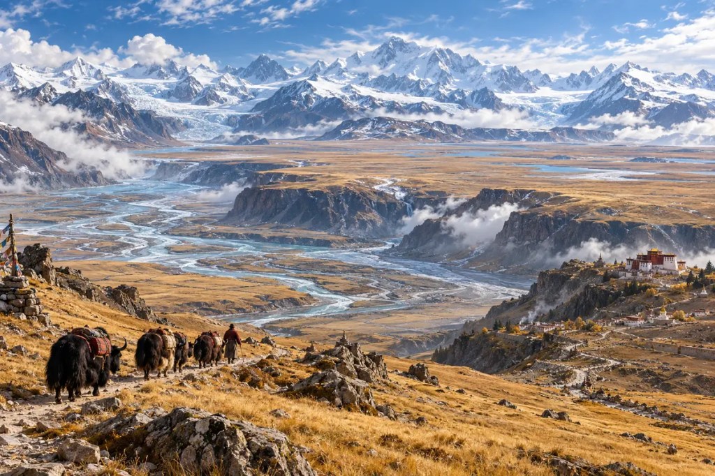
The Tibetan Plateau is sometimes described as the “roof of the world,” but height alone does not explain its power. Spanning a vast region at an average elevation of roughly 4,500 metres, it redirects winds, stores snow and ice, feeds major rivers, and imposes severe limits on farming and travel. Those physical conditions shaped distinctive forms of settlement, pastoralism, religion, trade, and political control—while linking the plateau’s future to the water security of much of Asia.
1. A Plateau Built in Stages
The Tibetan Plateau emerged from a long and complicated tectonic history. The northward-moving Indian plate collided with Eurasia, shortening and thickening the crust across a region already assembled from older continental fragments. Continued convergence raised mountains, activated major faults, and helped create the broad high terrain bordered by the Himalayas, Karakoram, Kunlun, and other ranges.
Geologists no longer treat the plateau as a single block that rose everywhere at the same moment. Different areas gained elevation through different processes and at different times. That uneven history matters: it produced interior basins, grasslands, lake districts, mountain chains, and deep river gorges rather than one uniform tableland.
2. The Roof That Redirects Air
Elevation gives the plateau a continental influence on climate. Its immense topography blocks and redirects air masses, while the land surface heats and cools strongly with the seasons. Together with the Himalayas and surrounding ranges, it interacts with the South and East Asian monsoon systems and with the westerly winds that cross Eurasia.
The plateau does not act like a simple wall with one predictable effect. Snow cover, soil moisture, surface heating, mountain barriers, and large-scale circulation interact differently from season to season. Even so, the central geographical fact is clear: a landmass of this height and area changes where moisture can travel and where rain and snow fall, influencing environments far beyond its margins.
3. Asia’s High Water Tower
Snowfields, glaciers, permafrost, lakes, and high-altitude wetlands store water across the plateau and its bordering mountains. Headwaters associated with this wider highland region feed river systems including the Indus, Ganges, Brahmaputra, Mekong, Yangtze, Yellow, and Salween. Their importance extends from mountain valleys to densely populated plains and deltas thousands of kilometres away.
These rivers do not depend on ice melt alone; monsoon rain, seasonal snow, groundwater, and basin conditions contribute in different proportions. Yet the highlands regulate the timing and reliability of flow, especially during dry periods in some basins. The plateau therefore joins distant societies through water: decisions and climatic changes upstream can affect agriculture, hydropower, ecosystems, and cities downstream.
4. Cold, Thin Air, and Human Adaptation
Low oxygen, intense ultraviolet radiation, cold temperatures, short growing seasons, and large daily temperature swings make permanent life difficult. Human occupation developed through biological adaptation, accumulated knowledge, clothing and architecture suited to cold conditions, and careful use of sheltered valleys, pasture, fuel, and water.
Settlement remained uneven. River valleys and lower northeastern margins could support denser farming communities, while broad interior grasslands favoured mobile or semi-mobile herding. Geography did not isolate every community in the same way; it created a mosaic in which altitude, slope, rainfall, and access to routes determined what kinds of livelihood were possible.
5. Barley, Yaks, and Pastoral Landscapes
Cold-tolerant barley helped make year-round settlement at high elevation more sustainable. Archaeological and genetic research indicates that farming populations moving through the plateau’s northeastern approaches adopted barley and contributed to permanent occupation of higher areas roughly 3,600 years ago. Barley became central to food systems because it matures within a short, cool growing season.
Across country too cold or dry for dependable crops, yaks, sheep, and goats converted high grasslands into transport, fibre, meat, milk, and fuel. Seasonal movement allowed herders to use scattered pasture without remaining in one exhausted place. This pastoral economy was not a primitive substitute for farming; it was a sophisticated response to altitude, climate variability, and the geography of rangelands.
6. Corridors Across a Barrier
The plateau hindered movement, but it never ended it. Valleys, passes, river corridors, and its lower margins channelled travellers between South Asia, Central Asia, and the Chinese interior. Pack animals carried salt, wool, tea, grain, metal goods, and religious texts through networks whose routes shifted with politics, climate, and local security.
Because usable passages were limited, places controlling them gained strategic and commercial importance. Trade was often seasonal and expensive, yet it connected pastoral and agricultural zones that needed one another’s products. The same terrain that made centralized control difficult also concentrated exchange into recognizable gateways.
7. Sacred Centres and Political Geography
Tibetan Buddhist monasteries became religious, educational, artistic, and economic centres across the plateau and neighbouring highlands. Sacred landscapes linked mountains, lakes, pilgrimage routes, and institutions, giving cultural meaning to physical geography. Lhasa grew in a sheltered river valley where access, agriculture, and political authority could converge.
Altitude and distance shaped government as well as faith. Local communities, monastic estates, pastoral territories, and regional powers operated across terrain where communication could be slow and seasonal. In the modern era, roads, airports, railways, dams, mining, and urban growth have reduced travel times and intensified state reach, but they have not erased the plateau’s environmental limits or cultural complexity.
8. A Warming Plateau, a Continental Risk
The Tibetan Plateau is warming rapidly. Glacier retreat, changing snow cover, thawing permafrost, expanding or shifting lakes, and altered vegetation affect roads, settlements, grazing, hazards, and the storage and release of water. The consequences vary among basins: additional melt may temporarily increase some flows, while long-term ice loss and changing precipitation can reduce reliability and intensify extremes.
Modern infrastructure and resource development bring electricity, mobility, services, and economic opportunity, but they also increase pressure on fragile soils, wetlands, and rangelands. Because so many rivers cross political borders, scientific monitoring and water management have international significance. The plateau’s remoteness no longer makes its changes remote from the rest of the world.
The Tibetan Plateau shaped civilization by turning altitude into climate, water, pasture, passage, and power. It fostered communities adapted to thin air and short seasons while feeding rivers that sustain societies far below. Today its greatest lesson is one of connection: changes on the roof of the world travel outward through winds, rivers, economies, and borders.
Further reading
- NASA Earth Observatory — Winter on the Roof of the World
- Nature Communications — India–Eurasia collision and the Tibetan Plateau
- National Science Review — Barley agriculture and permanent settlement
- Science Advances — Prehistoric dairying on the Tibetan Plateau
- FAO — Social, cultural, and economic context of yak production
- ICIMOD — Assessment of Snow, Glacier and Water Resources in Asia


Leave a comment