
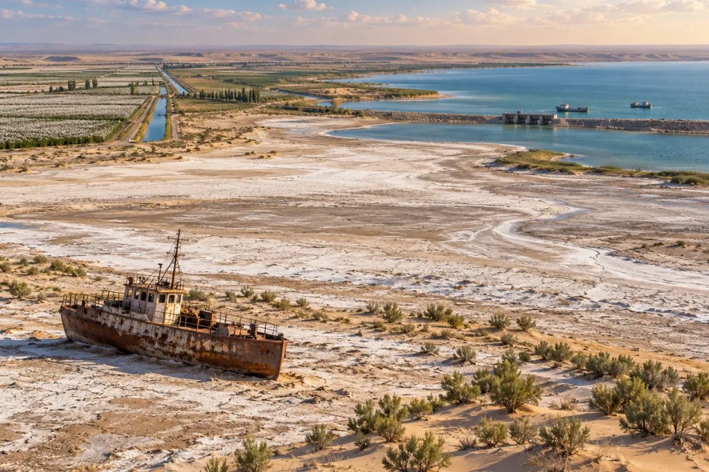
The Aral Sea was never connected to an ocean, yet for centuries it behaved like an inland world of its own. Fed by two great Central Asian rivers, it moderated a desert climate, supported fishing towns, and stood at the edge of irrigated civilizations. Its dramatic retreat in the modern era shows how geography can sustain societies—and how political choices can rapidly remake geography itself.
1. A Sea at the Bottom of a Basin
The Aral Sea occupied a low, enclosed basin between present-day Kazakhstan and Uzbekistan. Because it had no outlet to the ocean, its size depended on a fragile balance: water arrived mainly through the Amu Darya and Syr Darya, while evaporation carried water away under the region’s dry continental climate.
Those rivers began far beyond the shoreline, gathering snowmelt and precipitation from the mountains of Central Asia before crossing steppe and desert. The sea was therefore the final expression of an enormous watershed. Decisions made hundreds of kilometers upstream could determine whether water reached fishing grounds, wetlands, and delta communities downstream.
2. Oases, Fortresses, and the World of Khorezm
Long before the modern ecological crisis, people learned to divert parts of the Amu Darya into canals. Irrigated agriculture supported the oasis civilization of ancient Khorezm, whose fortified cities, temples, fields, and settlements developed amid the desert south of the Aral Sea.
This was not a landscape divided neatly between nomads and farmers. River channels shifted, oases expanded or declined, and towns connected sedentary agriculture with pastoral societies and wider Silk Road exchange. Water management made urban life possible, but it also tied political power to the maintenance and control of canals.
3. Cotton and the Reengineering of Rivers
In the twentieth century, Soviet planners expanded irrigation across the Aral basin on an unprecedented scale. Beginning especially in the 1960s, large volumes of water from the Amu Darya and Syr Darya were diverted to grow cotton and other crops on arid land.
The new canals increased agricultural production, employment, and settlement, but many systems lost water through evaporation, seepage, and inefficient delivery. As withdrawals grew, less river water reached the terminal lake. A project intended to transform desert into farmland steadily removed the inflow that kept the Aral Sea alive.
4. When the Waterline Withdrew
The retreat accelerated over the following decades. Once among the world’s largest inland water bodies, the Aral Sea fragmented into separate northern and southern sections. Former ports were left far from the shore, wetlands contracted, salinity rose, and commercial fisheries collapsed as aquatic habitats changed.
Where water disappeared, it exposed a vast salt-covered seabed that became known as the Aralkum Desert. Winds now carry dust and salts from this new landscape across the region. The transformation did more than shrink a lake on a map: it created an expanding source of land degradation and atmospheric pollution.
5. A Human Geography of Loss
Fishing towns lost the resource around which their economies and identities had formed. Processing plants closed, boats rested on dry ground, and workers migrated or sought new livelihoods. The former shoreline became a visible measure of economic distance: communities remained in place while the water on which they depended moved away.
Salt-laden dust, degraded soils, contaminated water, and a harsher local climate compounded the burden on public health and agriculture. The loss of the sea’s moderating influence contributed to hotter, drier summers and colder winters nearby. Environmental collapse became inseparable from questions of poverty, access to clean water, and regional inequality.
6. Independence and a Shared Watershed
After the Soviet Union dissolved, the rivers and infrastructure of the Aral basin crossed the borders of several independent states. Upstream countries sought water for hydropower, while downstream regions depended heavily on summer irrigation. The inherited network became both a shared necessity and a source of recurring tension.
No single country can manage the basin alone. Reservoir releases, crop choices, canal efficiency, energy demand, and ecosystem flows interact across borders. The Aral crisis therefore became a lesson in transboundary governance: cooperation is not an ideal added to geography but a practical requirement created by geography.
7. The Partial Return of the North Aral
The story is not only one of retreat. Kazakhstan completed the Kok-Aral Dam in 2005, separating the North Aral Sea from the lower southern basins and retaining more Syr Darya water. Water levels rose, salinity declined, and fisheries began to recover in the northern section.
This success was geographically limited: protecting the North Aral also reduced the water passing south, where restoration is far more difficult. Yet the project demonstrated that targeted engineering, reliable river flows, and local economic planning can revive part of a damaged ecosystem. It replaced a single story of irreversible disappearance with a more complicated map of loss and recovery.
8. Living with the Sea That Became a Desert
Across the exposed seabed, Kazakhstan and Uzbekistan are planting saxaul and other salt-tolerant vegetation to stabilize soil and reduce dust. Communities are also experimenting with climate-resilient agriculture, small-scale aquaculture, cleaner water systems, and new sources of income. These efforts adapt to a changed landscape even when they cannot recreate the former sea.
A durable future depends on using water more efficiently, reducing losses in canals, reconsidering highly water-intensive production, protecting delta wetlands, and coordinating river management across Central Asia. Restoration must address both ecosystems and livelihoods, because the crisis joined them together.
The Aral Sea is a warning written across an entire horizon: rivers can build civilizations, engineering can enlarge their reach, and political decisions can transform a living sea into desert within a human lifetime. Its partial recovery also shows that geography, once altered, can still respond to sustained cooperation and care.


Leave a comment