
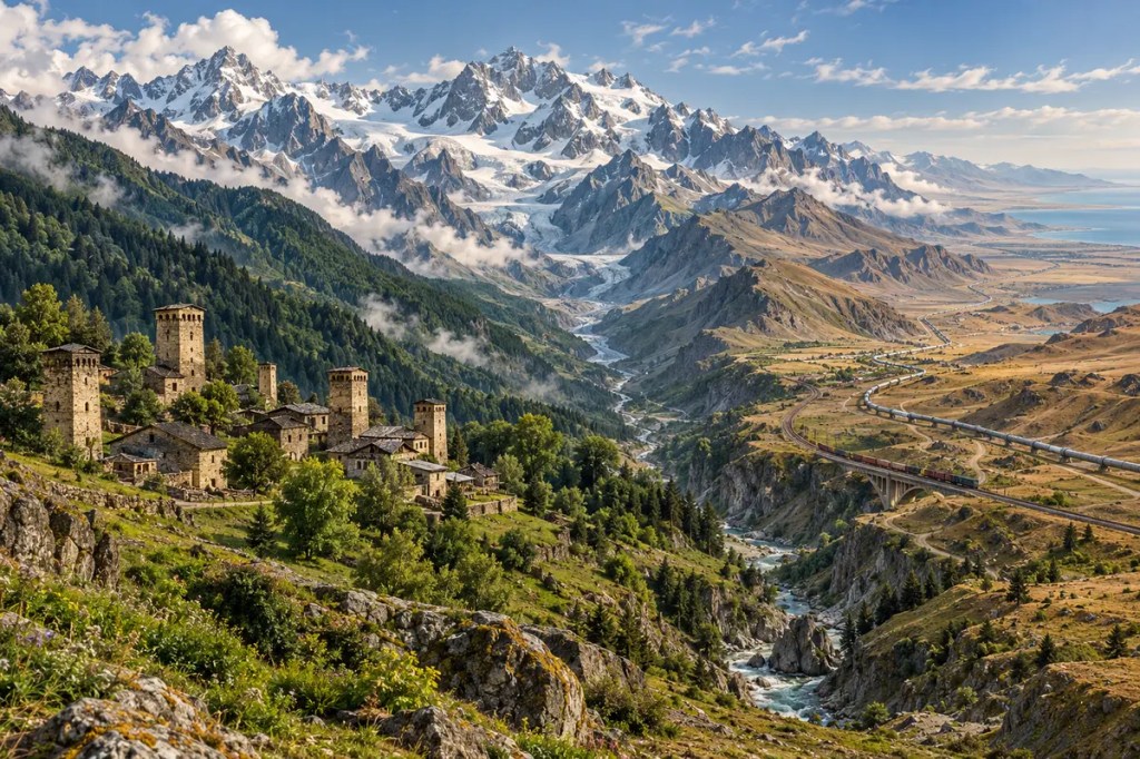
Between the Black Sea and the Caspian Sea, the Caucasus rises as far more than a line of peaks. Its ridges divide climates, its valleys shelter communities, and its narrow passages have repeatedly drawn merchants, armies, pilgrims, pipelines, and railways. Few landscapes show so clearly how a mountain barrier can also become a human corridor.
1. Mountains Born from Collision
The Caucasus belongs to the broad collision zone created as the Arabian plate pressed northward against Eurasia. The Greater Caucasus forms the region’s high northern spine between the Black and Caspian seas, while the Lesser Caucasus and adjoining uplands extend across the south. Compression folded, faulted, and lifted earlier rocks into an actively growing mountain system whose highest summits rise above 5,000 metres.
This geological youth is visible in the landscape: steep relief, deep gorges, unstable slopes, and frequent earthquakes. The same tectonic forces that built the mountains continue to deform them. For people living here, magnificent topography has always come with a practical lesson—settlement, roads, and agriculture must adapt to a ground that is both rugged and restless.
2. A Vertical Mosaic of Climate and Life
The range intercepts air moving inland from the Black Sea. Western slopes receive abundant moisture and support dense forests, while eastern districts become progressively drier toward the Caspian basin. Elevation adds another set of boundaries: lowland woodland gives way to montane forest, subalpine meadow, alpine grassland, bare rock, snowfields, and glaciers.
These compressed climate zones make the Caucasus an ecological crossroads as well as a refuge. The Western Caucasus preserves extensive mountain forests, diverse ecosystems, and many endemic plants and animals. Valleys and ridges separate habitats over short distances, encouraging biological variety while also making wildlife movement dependent on intact corridors across political borders.
3. Barrier, Passage, and Gate
For most travellers, the mountains could not simply be crossed anywhere. Movement concentrated through passes and along the lower coastal margins, turning geography into a map of strategic bottlenecks. Routes such as the Darial Gorge through the central range linked the northern steppe with the southern valleys, but snow, rockfall, and narrow terrain made every crossing seasonal and vulnerable.
At the eastern end, where the mountains approach the Caspian Sea, Derbent commanded a strip of plain only a few kilometres wide. Sasanian builders reinforced this natural gate with stone walls running from shore to mountain. The result captures a recurring Caucasian pattern: where the land permits passage, states build roads, towns, customs points, and fortresses to control it.
4. Valleys That Sheltered Languages
The same terrain that channelled long-distance travel also divided local life. High ridges, winter isolation, and enclosed valleys limited routine contact between neighbouring communities. Over centuries, that fragmentation helped sustain an extraordinary mosaic of languages, dialects, customary laws, religious traditions, and village identities within a comparatively small region.
Upper Svaneti in Georgia shows how isolation became architecture. Villages set among gorges and alpine valleys developed clusters of stone tower-houses that served as homes, stores, and defensive refuges. Their survival reflects not timeless seclusion but a durable response to the mountain environment: communities remained locally rooted while still participating in wider networks when passes opened.
5. Pastures, Vines, and Valley Agriculture
Mountain economies used altitude as a seasonal resource. Herds could move between sheltered winter settlements and high summer pastures, while valley floors and foothills supported grain, fruit, and vines. This vertical movement—often called transhumance—turned separate ecological belts into one working landscape and linked upland households with lowland markets.
In the South Caucasus, warm valleys and varied microclimates also encouraged early experimentation with grapes. Chemical evidence from Neolithic pottery in what is now Georgia indicates wine production in the early sixth millennium BCE. The finding does not reduce Caucasian agriculture to a single crop; it shows how a geographically varied borderland could become a long-lived centre of cultivation, storage, and exchange.
6. Empires at the Mountain Gates
The Caucasus stood between the steppe, Anatolia, Iran, and the Caspian world. Persian, Roman, Byzantine, Arab, Mongol, Ottoman, and Russian powers approached it from different directions, seeking defensible frontiers and reliable passages. Control was rarely uniform. Mountain communities could negotiate, resist, or change alliances because terrain made conquest easier along corridors than across whole ranges.
Derbent’s fortifications remained strategically important through successive regimes into the nineteenth century, while other passes became military roads and garrison routes. Yet conflict was only one form of movement. Caravan traffic, craft traditions, religious ideas, and crops also crossed the same gates, making the Caucasus both a frontier between empires and a workshop of cultural exchange.
7. Oil, Railways, and a Renewed Corridor
Industrial technology altered the scale of movement without erasing the old geography. Caspian oil made Baku a global energy centre, and railways sought practicable gradients through the South Caucasus toward Black Sea ports. In the modern era, roads, pipelines, and fibre-optic routes continue to favour the same broad east–west passage between the two seas.
Today that passage forms a central segment of the Trans-Caspian, or Middle, Corridor linking Central Asia with Türkiye and Europe. Its promise depends on more than laying tracks: ports, border procedures, digital systems, and cooperation among states must work together. The mountains still impose costs and chokepoints, but they also give the region strategic value as an alternative bridge between major markets.
8. A Shared Landscape under Pressure
Earthquakes, landslides, avalanches, and severe winters remain part of Caucasian life. Climate change adds a slower transformation as glaciers retreat and snow and water regimes shift. New roads and tourism can reduce isolation and support local economies, yet poorly planned construction can fragment habitats, destabilize slopes, and weaken the very cultural landscapes visitors come to see.
The range crosses borders, but rivers, ecosystems, hazards, and transport networks do not stop at them. Protecting migration routes, monitoring glaciers and faults, maintaining mountain settlements, and making corridors resilient all require cooperation. The Caucasus has never been merely a wall: its future depends on treating connection as carefully as defence.
The Caucasus shaped civilization through a productive contradiction. By obstructing movement, it preserved local worlds; by concentrating movement into a few gates, it made those worlds central to trade, strategy, and exchange between seas and continents.
Further reading
- U.S. Geological Survey — Total shortening estimates across the western Greater Caucasus Mountains
- UNESCO World Heritage Centre — Western Caucasus
- UNESCO World Heritage Centre — Upper Svaneti
- UNESCO World Heritage Centre — Citadel, Ancient City and Fortress Buildings of Derbent
- Proceedings of the National Academy of Sciences — Early Neolithic wine of Georgia in the South Caucasus
- World Bank — The Middle Trade and Transport Corridor


Leave a Reply